K to K Ski Trip July 1972
Saved by Brooks Hut
By Terry Linsell 30 June 2025.
This trip took place over a week fifty-three years ago so I may be a little hazy on the finer details.
I had done a few Main Range and Mt. Jagungal cross country ski trips previously with friends but had always wanted to do K to K (Mt Kosciuszko to Kiandra) – first skied I believe (in the other direction) by a party including Dr. Herbert Schlink in 1927.
Stephen Prescott and I were both young medical graduates in 1972. He also was keen to do K to K, but two is not a good safety number for an overland ski trip, so we advertised in a Canberra newspaper for a third skier. Hugh McKenzie answered the call so we had a threesome! I’m not sure now what occupation Hugh had and even if he is still around – we lost contact after the trip.
So we prepared our gear – fibre glass skis with no metal edges, bamboo stocks and Tempo bindings, foam mattress and alpine sleeping bag. We carried a tent between us in case of emergencies. Also stowed were rum and homemade scroggin, Paddy Pallin dehydrated meals (eg Farm House Stew aka Farm Horse Stew), Tang (a powdered orange cordial), survival gear, maps, compasses and whistles.
In those days you could catch a Pioneer bus from Canberra to Thredbo, which we did. Whether we stayed in Thredbo or not I can’t recall but on or about Friday 14 July we took the ski lift in goodish weather and skied from the top station towards Mt Kosciuszko, above Rawson Hut and finishing up at Lake Albina Lodge for the night. Now long gone, this was a private ski lodge that was not locked – so we availed ourselves of the luxury of real mattresses to sleep on. Little did we know that at that time two ski tourers were caught in a blizzard near Tin Hut, with one skier unfortunately losing his life from hypothermia.
The next morning we set off to traverse the Main Range towards The Rolling Grounds. The weather was initially clear but as the day progressed cloud and mist descended till our vision was severely limited.
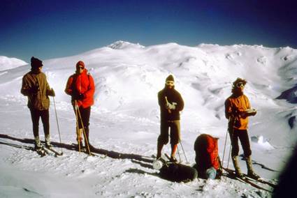
On the Main Range above Lake Albina.
Unknown, unknown, Hugh, Terry. Steve took the photo.
Although I always carried a camera, if I recall correctly all the photos in this story were taken on Steve’s camera (maybe an Olympus Trip 35), and they would have been on slides. So full credit to Steve.
Checking our map we decided to get off the peaks and head down to Illawong Lodge. This was (and still is) a private lodge but in those days it was not locked. We skied down towards the Snowy River, crossed over the suspension bridge and settled in for the rest of the day, to get out of the weather.
Next morning the Main Range was still obscured. We skied down to Guthega Dam and from there we skied/walked to Munyang Power Station. The snow was scattered at these lower levels and made for slow going.
At the hydro power station we found the workers’ amenity block and were amazed to find there was hot water in the taps! (Plenty of nearby power I guess). As the building was quite roomy we decided to camp therein – much better than outside!
By now it was probably Sunday July 16. As we set off up the weary, windy and steep fire trail towards Whites we were passed by people and police coming the other way. At the time we weren’t aware of the terrible tragedy that had happened. Later we worked out that the rescuers were probably bringing out the rescued skiers, one deceased.
It would have been a bit of a slog to Whites River Hut and we probably stayed the night there. As you can see we weren’t doing great daily distances but our packs would have been quite heavy.
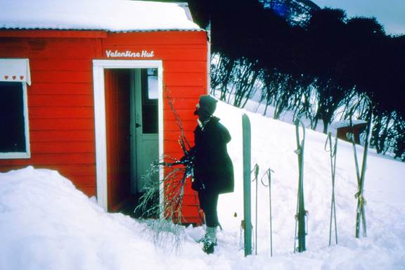
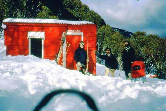
Next stop was Valentines where there was plenty of snow. The ski from Schlink Pass to Valentines was quite pleasant once you had climbed the hill at Duck Creek, I think it was called.
I don’t think we visited Grey Mare Hut on this trip as it was a little out of the way and up a steepish ridge.
I still recall the swishing sound of our skis, the snow laden trees and the awesome freedom. At one stage a large wombat trundled across our path. I’m not sure now what time we set out and what time we arrived but our next shelter was O’Keefes Hut. I was feeling a bit “off” with an attack of the runs so we decided to rest a day here. We thought we would try to build an igloo, to practice our survival skills – we learnt it was not a very practical idea as it took most of the day (using a snow saw) to complete it. We couldn’t construct the roof with snow so used sticks and branches.
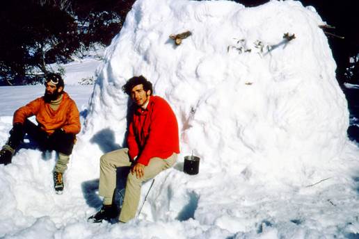
Terry and Steve – exhausted – plus one lumpy igloo.
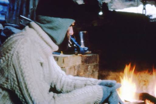
Terry, cosy near the fire – O’Keefes.
Up until now our trip, while a bit round about due to weather, was enjoyable. After O’Keefe’s we set a compass course for Brooks Hut. Not sure why we decided on that destination but maybe our timeline made us get a move on. Though we didn’t see them we would have passed by Mackays and Boobee huts – I haven’t gone back to check the maps so I’m not sure how close our course would have been.
Anyway we set off from O’Keefes fairly early I would imagine. Before long the weather deteriorated into rain and sleet, which then persisted the whole day. We were still able to see far enough ahead to stay on our compass course, so up and down we went. We eventually came to the Happy Jack Creek/River in the afternoon. We knew (I think) that there was a small wooden bridge somewhere but we could not see it so we took off everything below the waist and waded across the freezing water, ignoring the threat to the crown jewels.
All these years later I recall how cold and miserable we felt, even though we had all the right gear (for the era). Going through the frigid water did not help. Late in the afternoon the weather was still miserable and we started to look out anxiously for our destination, Brooks Hut. Vision was probably about one or two hundred metres.
We started ascending a slight ridge, all the while searching the gloom for the hut which we knew must be close. I recall Steve starting to laugh and thought he is either strangely very amused at our situation or was starting to show some evidence of hypothermia. I’ll never know. I know I was becoming very worried. Just when I thought we would have to find a sheltered spot, put up the tent and get into our sleeping bags I noticed something grey below us to the right. You guessed it – it was Brooks Hut. Holy Moly, what a welcome sight! The last couple of meters to the hut were downhill and we were soon counting our blessings in front of a beautiful fire.
In better weather we would not have had so much trouble finding the hut – but one thing you cannot count on in the mountains is the weather – it can change in a moment.
After a filling of farm horse stew or chilli con carne we must have slept soundly that night.
Next morning (probably Friday 21 July) we again set a compass course, this time directly for Kiandra.
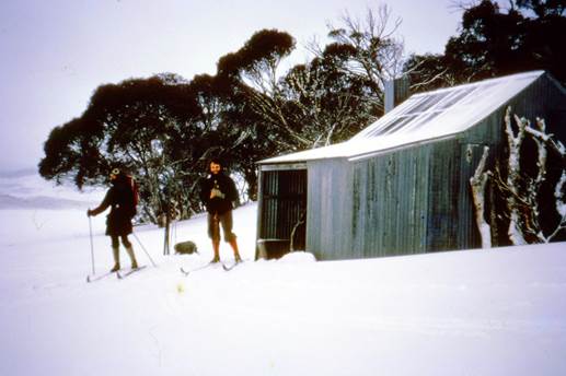
Terry and Hugh after a comfortable night at Brooks
The weather was not much better. On a direct course without good visibility we skied up hill and down dale. I recall going around Table Top Mountain but not much else till after a few hours struggling through patches of soft snow we found ourselves amongst tombstones! I thought “did we succumb and cross over to the cold side?”
No, we were in the Kiandra Cemetery! It was a kilometer or two near the road on the Adaminaby side of Kiandra. We had made it! A (fair) bit off course but thanks to the road we knew where we were.
We trudged up the hill to the Kiandra Pub and walked into the tiny bar, feeling like heroes. Unfortunately there were no other patrons to admire us. Steve rang a friend in Adaminaby who soon came and picked us up. While waiting we had a few well earned ales.
I realise that while we had a certain level of bush, snow and navigation skills and were young and fit (I was 26) we also could have ended up in a similar situation to the unfortunates at Tin Hut. While we were not struck by a blizzard the weather had not been kind.
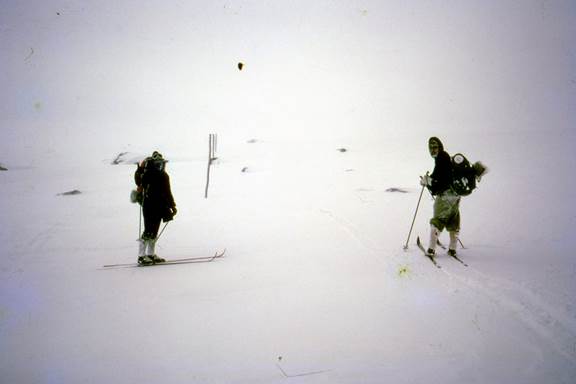
Somewhere on the trek
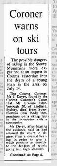
Canberra Times Sat 12 August 1972
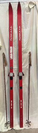
My old skis
Tempo Bindings from Norway.
Skis from Finland.
Notes:
- Some years ago I was wondering about KNP hut log books and what happened to them as they filled up. My research led me to a government archives establishment in Hurstville, Sydney. There I found our entry in Brooks log book during that trip.
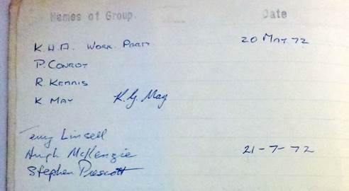
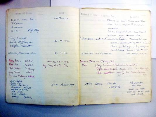
Some famous names there (Paddy Pallin). Steve describes our adventure well – on the right.
- There was of course no GPS in 1972, no LED lights, no Gortex and not the variety of very light dehydrated meals that now abound.
- Sadly Steve is no longer with us. If Hugh or family or friends or acquaintances are still out there I would like to hear from you.
- We did have a way of navigating in a whiteout. If you knew where you were and where you wanted to go you firstly took a (magnetic) bearing on the map. Then you would get your partner to walk/ski out with the end of a long string till he could just be seen, then tell him to move left or right till the string aligned exactly with the course bearing. Then you would walk up to him and repeat the procedure till either the weather cleared or you reached your destination. Of course, you had to make sure from the map that there would be no cliffs, rivers or other unseen dangers in your path.
- I still have waxes and klisters from that time (I’m a hoarder) – not sure if we used them on the trip.
- All errors or omissions are my fault. This account is from memory as I did not keep a diary, nor have I checked my old maps.
- I am sorry if I have stirred up sad memories for the family of the lost skier.
- Copyright is mine.
Thanks for reading this
Terry Linsell